

i-Boating:Marine Navigation
Use LDPlayer to Play i-Boating:Marine Navigation on PC
i-Boating:Marine Navigation is a Travel&Local application developed by Gps Nautical Charts, but with the best Android emulator-LDPlayer, you can download and play i-Boating:Marine Navigation on your computer.
Running i-Boating:Marine Navigation on your computer allows you to browse clearly on a large screen, and controlling the application with a mouse and keyboard is much faster than using touchscreen, all while never having to worry about device battery issues.
With multi-instance and synchronization features, you can even run multiple applications and accounts on your PC.
And file sharing makes sharing images, videos, and files incredibly easy.
Download i-Boating:Marine Navigation and run it on your PC. Enjoy the large screen and high-definition quality on your PC!
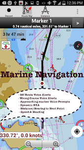
This Marine Charts App offers offline nautical charts, inland river navigation charts, and lake contour maps for fishing,kayaking, yachting & sailing.First marine navigation app to have boat route assistance with Voice Prompts. All features of a Marine Chart plotter in one app!
It supports Nautical Charts course up orientation. Incl Tide Charts & Currents prediction for nautical navigation.
Create new boat routes / Waypoints, or import existing GPX/KML routes on device. Has Marine AIS(NMEA) support.
►FEATURES
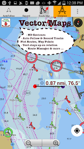
√ GPU accelerated offline vector NOAA charts/ENC charts (text stays upright on rotation)
√ Lake depth map shading/safety lake depth contours:custom boat safety depth
√ Maritime Aids to Boat Navigation : Beacons,Buoys,Boat Launch areas,Boat Ramps,Marina, Fishing Attractors
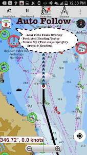
√ Record marine tracks, Autofollow with real-time track overlay
√ Voice Prompts for marine navigation
√ HD 1ft/3ft depth lake contour maps for anglers for selected lake maps: for fishing/trolling(freshwater/saltwater).
√ GPX/KML for boat route.
√ Seamless marine chart quilting: Details from Coastal, Approaches,Harbour & Inland ENC (Electronic Marine Charts)
√ Waypoints
√ Tide & Currents.
√ Marine AIS
√ Anchor Alarm
√ Magnify Text & Icons
√ Wind Prediction Overlay
√ Bearing True/Magnetic
► Fishing Hot Spots AI
► Lake Temperature Maps(Thermoclines accurate to 1°F (0.5° C)
► Relief Shading
► MAPS
All details of marine chartplotters!
Unlimited updates for 1 year.
USA: Maps incl coverage of NOAA marine charts,ENC,USACE inland river maps & freshwater lake bathymetry maps for more than 50K lakes. Charts incl HD/1ft bathymetry for selected lakes. Incl NOAA marine charts(rasters) w/ NOAA ENC coverage.
Canada:CHS data Incl Great lakes(US & Canada sides),Alberta & Ontario lakes,Lake Simcoe&Trent Severn Canal,Quebec reservoirs.
UK/Ireland: UKHO marine charts
Germany:BSH charts,Waterways & rivers.
France
Europe Inland Rivers:Donau/Danube/Dunaja,Rhine,Rhein,Garonne,Moselle,Drava,Sava
Australia
Netherland/Holland
Croatia
Finland
Norway
Sweden
Brazil
Spain
Malta,Cypress, Mediterranean Sea
Caribbean
New Zealand
Denmark,Greenland,Faroe
Seychelles,Mauritius,Tanzania
Falklands
Malaysia,South China Sea
Persian/Arabian Gulf,Red Sea
South Africa
Argentina
Iceland
Fiji
Estonia,Latvia,Poland,Lithuania
Turkey,Greece,Italy
►Instrumentation
√ Marine AIS & (NMEA AIS and GPS - TCP/UDP)
√ Wind direction & Speed,Marine Sonar depth,Water temperature
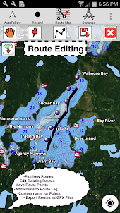
►ROUTE MANAGEMENT/TRIP PLANNING
√ Create/Edit/Reverse Boat Routes
√ Waypoints mgt
√ Import GPX,KML & KMZ files
√ Share/Export Routes,Boating log,Tracks&Markers
►FEATURES for BOAT NAVIGATION
√ Auto Follow
* Real Time Overlay & Predicted Path Vector
* Course Up
* Speed & Heading
√ Route Assistance With Voice Prompts
* approaching boating route marker prompt
* Real time nautical distance & ETA
* sailing/boating off route/wrong direction
√ Record Tracks
►TIDE & CURRENTS
* High/Low Tides
* Tidal Current Prediction
►Marine Weather
*GFS + ECMWF
► SHARING
* Tracks/Boat routes/markers/Waypoints
* Export GPX.
► Satellite Imagery
► USA Marine Charts
*Texas Lakes: Texoma,Eufaula,Toledo Bend
*California Lakes:Tahoe,Shasta
Pennsylvania Lakes: Raystown
Florida Lakes: Okeechobee,Kissimmee
*Minnesota Lakes: Minnetonka,Waconia,Leech,Mille Lacs
* Massachussets lakes Quabbin
*Missouri Lakes: Truman
*Ohio Lake maps Lake hoover
*Wisconsin Lakes: Winnebago,Pepin
* Utah Lake Powell,Bear
*Maine Lake Sebago
*Alaska Lakes:Winnipesaukee
*Tennessee Lake Barkley,Norris,Watts Bar
*South Carolina Lake Keowee,Hartwell,Murray
*Lake Michigan,Huron,Ontario,Superior,Erie
►Canada Lakes Maps
*Lac Saint Jean
*Ontario Lake depth maps
*Rideau Canal-Ottawa River
*British Columbia Marine Charts
*Pacific Coast-Vancouver- Haida Gwaii
*Nova Scotia South-Bay of Fundy
*Quebec-Anticosti Island
*Newfoundland
*St. Lawrence river
*Manitoba & Saskatchewan
*Georgian Bay
*Puget Sound
►UK Nautical Charts
*Scotland
*Thames Estuary
*Ireland
►Australia Marine & Lake Maps
*NSW
*Queensland
Screenshots and Videos of i-Boating:Marine Navigation PC
Why Play i-Boating:Marine Navigation on PC with LDPlayer?
How to Download i-Boating:Marine Navigation on PC?
Download and install LDPlayer on your computer
Locate the Play Store in LDPlayer's system apps, launch it, and sign in to your Google account
Enter "i-Boating:Marine Navigation" into the search bar and search for it
Choose and install i-Boating:Marine Navigation from the search results
Once the download and installation are complete, return to the LDPlayer home screen
Click on the game icon on the LDPlayer home screen to start enjoying the exciting game
If you've already downloaded the APK file from another source, simply open LDPlayer and drag the APK file directly into the emulator.
If you've downloaded an XAPK file from another source, please refer to the tutorial for installation instructions.
If you've obtained both an APK file and OBB data from another source, please refer to the tutorial for installation instructions.
Haven't been on the water yet but I have played with the pro version app on the phone and PC (I will be buying that soon) and really like the looks and feel of it so far. I did change phones and had an issue re-attaching my Google account to it, but they were super quick to assist me. I will update with more after I have used it on the water but so far I'm impressed.
Resolved! [After paying for the Canadian charts it doesn't recognize I paid for it in the apps store... Therefore I cannot install it on my tablet after I purchased it on my phone. My intended use was to be on my tablet. So it seems I will have to pay for it again on order for me to have it on my tablet. Not happy.] Rated 2 stars. Support contacted me with a product key and instructions. I entered the key and immediately the app response accordingly. Thank you! 5 Star app and service.
Love this app,I use it on coastal inland bays. this app is so smooth on time. I always now where I'm at real time. Wonderful job! Update: Well it seems my $20.00 purchase has expired and I can no longer use the features or the map I bought to use with them. Guess this app isn't for sale. Well the search goes on for a good back-up! For the fact that you can't purchase the app I'm gunna hafta rate it 2 stars.